Book a demo

Google Manager Joins Targomo as CEO to Expand Startup’s Location Analytics Services

Feb 04 2020 Published by under Blog

Former Google manager Patrick Schoenemann has joined Targomo as CEO to expand the Berlin startup’s presence in the location and data analytics market. It is another high-level addition to the Berlin-based software maker, which had already attracted a former Nokia director and raised funding from venture capitalist Earlybird.

Patrick Schoenemann joined Targomo as chief executive officer and managing director on February 1 to strengthen the startup’s offering to businesses and public organizations. Patrick had been building up Google’s operations in Europe since 2006, running various positions within the Google Maps Enterprise business.

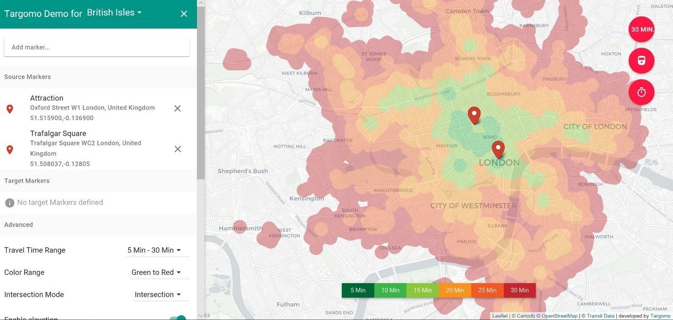
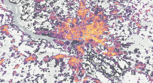
Targomo offers sophisticated mapping and location software, allowing managers to make intelligence business decisions based on location data. For example, the software predicts revenues of retail stores, forecasts the attractiveness of new offices before they are constructed, or optimizes public transportation networks to deliver the best possible service to commuters. Targomo’s cloud-based software is also able to analyze vast amounts of data to plan and update logistics routes, making sure goods are delivered on time and at minimal costs.

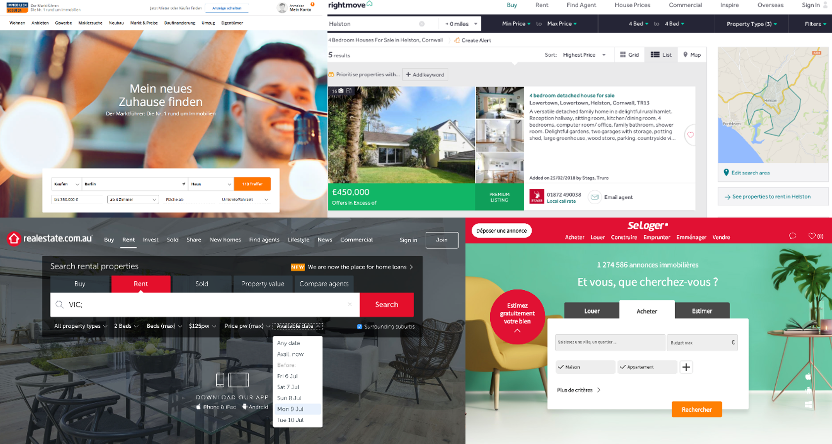
The Berlin-based startup has already won a wide range of customers across different industries and countries. Its clients include Oxford Retail Consultants in Britain, French telecoms group Orange, Dutch real estate platform Funda, Oslo’s public transportation authority Ruter, and German beverages retailer Getränke Hoffmann, among others.

“As an internationally experienced business leader, Patrick will expand our global position.” said Henning Hollburg, Targomo’s founder and managing director. “He has a deep understanding of geospatial information, and how businesses and public departments could use this data to generate insights and predictions to serve their customers. With his experience and background, Patrick is a natural fit for Targomo. It will be his mission to lead Targomo to sustainable growth and make us the market leader for location intelligence. His presence will allow me to focus on improving our technology.”

Scaling up

After 14 years with Google, Patrick felt inspired by Targomo to take the next step in his career and lead the Berlin-based startup. “Targomo offers state-of-the-art software to analyze and answer highly complicated location questions. I am deeply impressed how Targomo pioneers location intelligence and artificial intelligence, yielding extremely valuable insights. These will help organizations to forecast what customers need at what time and where exactly,” said Patrick. “This is the next chapter of how location-based services will help organizations to plan their future. I am looking forward to taking part in this exciting endeavor and work together with the team to bring Targomo’s services to clients across the globe. It is a unique chance to build up a company with a highly advanced technology that serves organizations and people at the same time.”

[quote text=”This is the next chapter of how location-based services will help organizations to plan
their future.” type=”long” name=”Patrick Schoenemann” role=”CEO at Targomo”]

Targomo has steadily expanded and received funding from European venture capital firm Earlybird in 2018. Last year, Targomo launched TargomoLOOP, a stand-alone platform which managers and employees without a coding background can use to gain insights into how to improve performance. In the same year, the company also hired Chand Malu, an engineer in information technologies who has worked at Nokia in Finland and India, and several tech companies in Germany.

“Following Earlybird’s participation and Chand’s engagement as senior product manager, Patrick will help us to further scale up our operations and bring our customers the location insights they need to gain a competitive advantage in fast moving markets,” said founder and managing director Henning. “At the core of our services is a routing technology that allows us to know exactly how much time people need to reach a location. By combining this reachability analysis with socio-economic demographics, data about movements and points of interest, and proprietary figures we can predict the performance of network changes and expansions.”

In 2013, Henning Hollburg founded Targomo together with Marc Hildebrandt, a successful German tech entrepreneur who supports Targomo as Executive Chairman and with his holding German Deep Tech. Before establishing Targomo, Henning completed his studies in Potsdam and Karlsruhe focusing on Cartography and Computer Science. The idea for Targomo came from a university project at the renowned Hasso Plattner Institute in Potsdam while Henning was writing his Master’s Thesis about the interactive analysis of reachability in large transportation networks. Henning dedicated his thesis to this topic after he had tried to find an apartment that he could reach quickly from his university.


About Targomo:
Bringing together advanced location analysis & artificial intelligence, Targomo helps organizations generate data-based insights and forecasts to boost performance. Founded in 2013 and based in Berlin and Potsdam, Targomo offers location intelligence solutions that convert complex geospatial research into actionable insights. These allow customers to optimize their retail networks and predict performance, deliver better public services, and to improve real estate search and logistics routing. More information: www.targomo.com

About German Deep Tech:
The German Deep Tech Group has been founded by serial entrepreneur Marc Hildebrandt. Together with the Hasso Plattner Institute for Digital Engineering (HPI) as excellence partner, the holding converts outstanding research results in software engineering, advanced analytics and information cartography into scalable growth companies, developing them sustainably. The portfolio includes several deep tech startups, among them Seerene, an AI-based end-to-end software analytics platform, Targomo, which leverages location intelligence to optimize business decisions, and Point Cloud Technology, a platform for automated point cloud analysis based on machine learning. More information: www.germandeeptech.com

About Earlybird:
Earlybird is a venture capital investor focused on European technology companies. Founded in 1997, Earlybird invests in all growth and development phases of a company. Amongst the most experienced venture investors in Europe, Earlybird offers its portfolio companies not only financial resources, but also strategic and operational support as well as access to an international network and capital markets. Earlybird manages separate funds focussing on digital technologies in Eastern and Western Europe as well as healthcare across Europe. With over EUR 1 billion under management, seven IPOs and 24 trade sales, Earlybird is one of the most successful venture capital firms in Europe. More information: www.earlybird.com

Not for publication:
For more information, interview requests, or high-resolution images, please contact Gilbert Kreijger,
marketing and communications manager, Targomo
Email: gilbert.kreijger [at] targomo.com

Comments Off on Google Manager Joins Targomo as CEO to Expand Startup’s Location Analytics Services

Targomo hires Google manager Patrick Schoenemann as new CEO

Feb 04 2020 Published by under In the Media

Comments Off on Targomo hires Google manager Patrick Schoenemann as new CEO

Spanish newspaper El Pais used Targomo software

Jan 19 2020 Published by under In the Media

Comments Off on Spanish newspaper El Pais used Targomo software

ProgrammableWeb’s Most Clicked, Shared and Talked About APIs of 2019: Mapping and Location

Jan 01 2020 Published by under In the Media

Comments Off on ProgrammableWeb’s Most Clicked, Shared and Talked About APIs of 2019: Mapping and Location

How to Select the Ideal Branch Location with Gravitational Models

Nov 08 2019 Published by under Whitepapers

Comments Off on How to Select the Ideal Branch Location with Gravitational Models

Webinar: How to leverage Geo AI for Retail Sales Forecasting (English)

Nov 08 2019 Published by under Webinars

Comments Off on Webinar: How to leverage Geo AI for Retail Sales Forecasting (English)

Mastering the Digital Challenges in Urban and Rural Areas

Nov 05 2019 Published by under Blog

The Smart Country Convention 2019 provided a great overview of the challenges that digitalization brings to urban and rural areas. We’ve learned a lot from the bright and purpose-driven speakers, presenting their innovative solutions and strategies.

The digitalization of the Public Sector, in Europe and in Germany takes place in societies that are heavily urbanized. Urban areas are currently housing 72% of the EU-28’s population. Rural populations on the other hand showed a steady decline over the last 50 years; in 1960, 35% of Europeans lived in rural areas, compared to 28% in 2010. Germany is not an outlier of this trend.

While digital services can improve and soften the impact of urbanization, they can also exacerbate existing problems. Rapid advancements in technology and social change challenge the political realities on the ground and public officials need to show that they are able to create a smart and sustainable future for their citizens.

The challenges of digitalization also differ vastly between rural and urban areas, especially when it comes to mobility and the provision of public services. In recent years, cities have witnessed a profound change in mobility patterns. New forms of individual mobility services such as car-, ride- and bike-sharing shape our daily lives. These services lead to new spatial demands, like designated parking facilities and charging infrastructures. While traffic behaviour in German cities is increasingly multimodal, the private car remains the number one means of transport in rural areas: 72% of residents depend on their own car or two-wheeler. Furthermore, 70% of workers living outside urban centres travel by car to work, regardless of commuting times.

Rural areas: Challenges and Solutions

The mayor of Bad Nauheim, Klaus Kreß, presented his city’s approach towards digitalization at the Smart Country Convention. Bad Nauheim, is a great example how digitalization can help a city reinvent itself. Before the reunification of Germany, Bad Nauheim had the oldest population in the whole country. Since then, they decided to tackle this problem head-on with new digital tools while keeping in mind local traditions and concerns. According to the Mayor, there are clear goals for digitalization in the rural context: Problem solving, sustainability and efficiency, enhancing experience and creating an innovative identity. With this in mind, digitalization can be a major driver for sustainable, innovative urban development, but also for more identification and experience. Dr. Stephanie Arens from @suedwestfalen presented a different solution: Coming together as a region. [quote text=”Digital, sustainable and authentic: that’s the DNA of our digital strategy as a region.” type=”long” name=”Dr. Stephanie Arens” role=”Head of Regional Development at suedwestfalen”] Suedwestfalen is a development company founded to develop a concept for a digital future with 59 cities and communities of this West-German region. This innovative private-public venture bundles the strengths of business and politics to set up the region for growth and innovation.

eGovernment on the rise in German cities

Cities are using the benefits of sharing capacities to their advantage as well. The mayor of mid-sized German city Ulm (122.000 inhabitants) described how his city only tackles certain questions like mobility, energy, infrastructure together with surrounding cities. This way they managed to work on a coherent strategy and save costs.

Thomas Bönig (CIO Munich) on stage at the Smart Country Convention 2019

Munich’s Chief Innovation Officer, Thomas Bönig, presented the city’s three strategic pillars for handling the digital revolution: Firstly, meet citizens where they are, don’t stop new developments that emerge from the bottom-up. Secondly, no city is an island, using interdependencies and cross-pollination between cities to be more efficient. Thirdly, it’s crucial to find the middle ground between individualized focus and standardized best practices.

All of these efforts are bundled under one umbrella agency, Munich Digital. Their vision: Make Munich by 2025 a future-oriented and sustainable metropolis that uses digitalization actively and responsibly – for the benefit of its citizens, making it possible for everyone to digitally experience Munich.

Smart City Index: Quantifying German digitalization

While these anecdotes were certainly enlightening, Bitkom Research went one step further to understand the whole picture of Germany-wide digitalization. They collected, checked and qualified a total of 7,800 data points. All 81 German cities with at least 100,000 inhabitants were evaluated in five areas: Administration, IT and telecommunications infrastructure, energy and the environment, mobility, and society. Learn More

The 20 smartest German cities according to bitkom.

While many of the examples mentioned in this article and the Smart City Index, are shining examples of a smart future, it is also clear that the road ahead is difficult and mistakes will be made.

Location Intelligence’s role in managing the digital transformation

One example for the difficulties of digital solutions are E-Scooters. We already touched upon this phenomenon in this recent blog post. Right now, the research suggests that e-scooters are nothing more than another mobility gadget for urbanites: They dominate in city centers but are mostly vacant in outer-city areas where they could solve the problem of the first mile: Getting people to the next public transport station, and thereby eliminating the need for expensive infrastructure expansions to all corners of urban settlements.

With Location Intelligence, city planners can better arrange parking zones and routes and make a tangible impact on public transport efficiency.

The electrification of public transport networks in Europe will be an iterative process that changes with the needs, quantity and preferences of its citizens. Such networks will need to be flexible and open to new electrified vehicles for urban transportation. Targomo’s data-driven approach can help public sector officials optimize the planning phase of electrified public infrastructure projects, analyse the results after implementation, and effectively plan for future projects.

We are already helping our innovative customers such as Ruter#, Oslo’s public transport authority, to optimize their public transport network and deliver better services to their citizens.

Are you interested in how Location Intelligence can support the Public Sector? Find out more on our website.

Comments Off on Mastering the Digital Challenges in Urban and Rural Areas

Business Geomatics 3/18

Oct 29 2019 Published by under In the Media

Comments Off on Business Geomatics 3/18

Optimize Public Services with Location Intelligence

Oct 15 2019 Published by under One Pagers

Targomo empowers policy makers and municipal managers to rise to the challenges of public planning with location intelligence. Optimize public services.

Comments Off on Optimize Public Services with Location Intelligence

For Real Estate Search, Disruption is Around the Corner

Sep 17 2019 Published by under Blog

In terms of real estate search, it seems as if little has changed in recent years. Today, it seems to be only a matter of time until new technologies, based on big data, will radically change the customer experience in the real estate search market.

The last major revolution of property search happened about twenty to twenty-five years ago. Back then, the only way to find properties was either by engaging a realtor or by studying print media. This meant tedious and time-consuming screening of property ads and finding supra-regional real estate was almost impossible. Everyone was completely dependent on the realtor – from property owners, landlords, tenants, to buyers. Nobody was able to get a complete, transparent overview of the market.

Later, in the late 1990ies, the first online real estate platforms such as immowelt.de (1994), followed by realestate.com.au (1995), seloger.fr (1996), immobilienscout24.de (1998), rightmove.co.uk (2000) and trulia.com (2004) were on the rise, and with them, property search underwent a radical Transition.

Various Real Estate Portals

User-friendliness as the key to success

Online market places such as immowelt.de dramatically revolutionized the real estate market. Suddenly, it was possible for the user to search for supra-regional properties and comparing prices became effortless; a single ad reached a significantly bigger audience and administrative expenses decreased for landlords, realtors, and property owners.

The time-consuming search for real estate got easier for property seekers as well. Potentially avoidable on-site visits were prevented, as preferences regarding price and facilities simply could be entered online. Comparing real estate had just become a whole lot easier. It was this new level of user-friendliness that caused the major shift away from print media and towards the online segment in the real estate portal business.


Little innovation due to low competition

Today, the market is well represented by up to three real estate platforms in each country with little differences among each other. The reason is simple: the way prospects can search for property has stayed the same for twenty years. While there are different versions for various devices and the design is more appealing than twenty years ago, the underlying search mechanisms remained the same. The user has to know where and what kind of property he or she is looking for. In consequence, real estate portals only benefit those who have already made up their minds by about 80%.

Yet, the decision-making process for real estate works completely different. Rather than considering whether the portal’s displayed ads are a fit, prospects want to decide on the basic qualifications of a location and its surroundings first.


Intelligent algorithms already help in the early stages

Choosing the right location is a highly individual decision and normally beings with questions of connectivity and travel times from and to potential places of residence. This is a simple task for a prospect who has already decided on one or more potential locations. However, since all online analysis tools require a more or less specific location to start the search, if one hasn’t decided on a location yet, current online solutions won’t be able to help. That being said, today’s technology is already capable of doing what the prospects need – choosing the best location by considering certain demands.

Here’s an example:

Person A’s workplace is in Oxford Street and his/her partner works at Trafalgar Square – both want to reach their workplaces in approximately the same time. Which areas should they consider for their new apartment?


Targomo's Reachability Analysis

Image Source: Targomo.com – Demo British Isles; Calculation of travel time with public transportation in London; displayed in polygons

The graphic above shows potential places of residence from which both can reach their workplaces in approximately the same time. Using this technology, the map also reveals certain patterns which no one, including experienced realtors, could have predicted.


Current solutions miss out on the technological potential

In the mentioned example, the prospect can now compare and evaluate the various displayed suggestions for a place of residence. In this context, surroundings of a potential location play a vital role. Depending on one’s individual requirements, different questions emerge:

  • How good is the care and supply situation regarding doctors, kindergartens, schools, municipal institutions, and others?
  • What does cultural life offer: restaurants, bars, bakeries, cafes?
  • What is the neighborhood like?
  • Is the district safe?
  • What kind of sports clubs exist?
  • Is there sufficient parking?
  • How high are the rental prices?

All these aspects must be part of the analysis now. There is plenty of data available for these questions and, partially, platforms are already visualizing single aspects such as kindergartens and schools in the surrounding area.

Real Estate Platform Trulia

Image Source: Trulia.com; a good example how the US property search portal takes some of this data into account.

Yet, most portals require a specific location as a prerequisite to take these aspects into consideration. This means that although it’s possible to create an environment analysis for a single real estate offer, this information doesn’t provide any value for someone who wants to choose their location depending on the surroundings – and not the other way around. The prospect wants to make a weighed decision regarding the potential place of residence.


New technology is here – disruption is coming

Interestingly, state-of-the-art technology is already capable of processing the available data to compare different regions, and to find the potential place of residence without looking at a single listing – promising to significantly simplify real estate search.

Looking into the near future, the next generation of real estate portals will move the prospect’s needs into the center of attention – because as history has shown before, it’s what users like that wins the race.


If you’re interested in upgrading your real estate portal, you can download our free Whitepaper. It gives many details on how to use our API in order to grant your users a new search experience.

Comments Off on For Real Estate Search, Disruption is Around the Corner

« Prev - Next »

We use cookies on our website. They provide us with web analytics, helping to give you the best possible experience on all pages. To learn more and see a full list of cookies we use, visit our Privacy Policy

Essential Cookies
Google Analytics
HotJar
We use cookies on our website. They provide us with web analytics, helping to give you the best possible experience on all pages. To learn more and see a full list of cookies we use, visit our Privacy Policy.
These cookies help us understand how you use the website — which pages are most visited, how long users stay, and how they navigate. All data is anonymous. Enabling these helps us improve the site.
These cookies track clicks, scrolling, and how you interact with content. They allow us to analyze usage through heatmaps and session recordings. You can disable these if you prefer not to share this type of data.