Affordable Housing around Vienna, Austria: When Commuting Pays Off
Comments Off on Affordable Housing around Vienna, Austria: When Commuting Pays Off


Comments Off on Affordable Housing around Vienna, Austria: When Commuting Pays Off
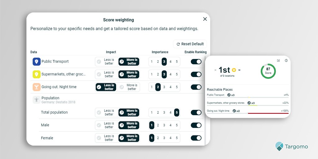
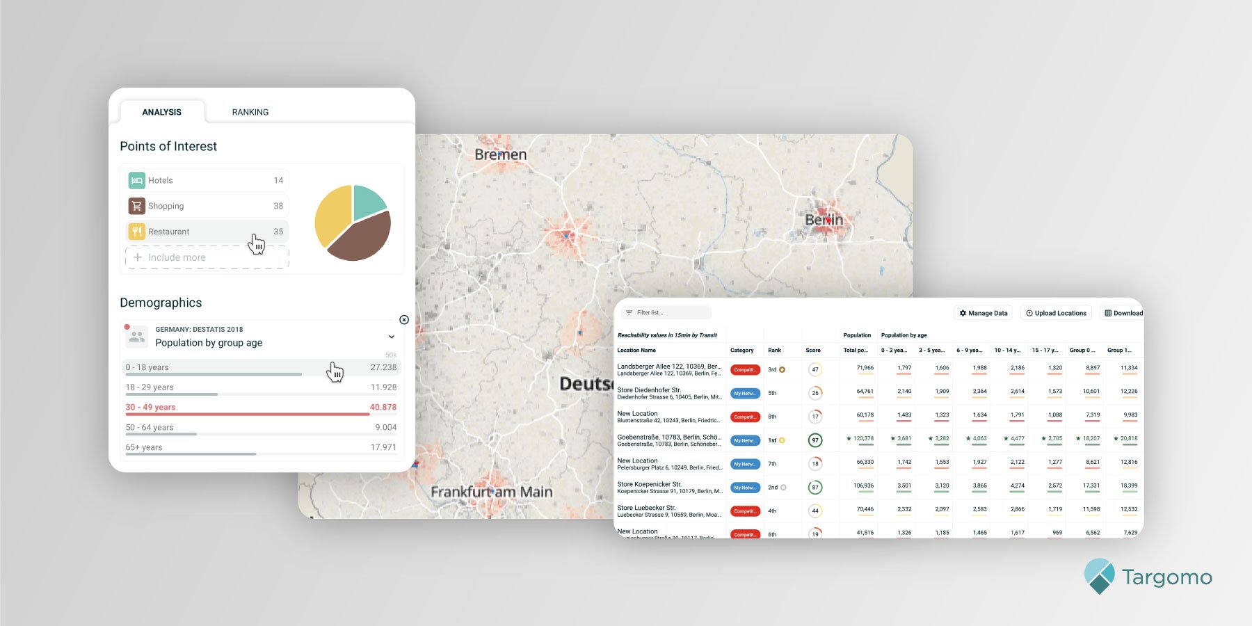
Businesses looking for the best locations can now very quickly identify which sites best match their specific requirements. In location analytics platform TargomoLOOP they can rank locations by assigning weights to criteria most relevant to them.
Each business needs a specific area to thrive. For some stores, households with children are crucial, while the presence of offices has a negative impact on revenue. For restaurants the presence of high footfall is important, while the vicinity of supermarkets could be detrimental to business.
Finding the locations that match these individual location parameters is now easier with a new weighting feature in Targomo’s location analytics platform TargomoLOOP. In the example with the stores above, the feature allows a retailer to add a high weight to the variable households with children and a low or negative weight to the presence of offices.
Of a list of potential locations, TargomoLOOP can now easily rank all these sites and give an individual scoring to every location, using the weights. Locations in areas with more households with kids will get a higher score, while those with many offices in their vicinity get a lower score. The result is a ranking list of locations customized to the specific needs of the business, in this example a certain retailer.
Noel Carbo, Product Manager with Targomo, says: “Many location questions require a customized analysis of location variables. By adding weights to each demographic variable and reachable places category, our customers can precisely find the locations that best suit their business. Weighting greatly improves the value of our scoring and ranking analysis, resulting in better location recommendations.”
Many businesses and organizations, from retailers to restaurants and bakeries, from real estate to mobility services, can benefit from TargomoLOOP and the new weighting feature. They can make detailed analyses of locations, catchment areas, and neighborhood characteristics.
The basic version of TargomoLOOP is free of charge and allows users to quickly gain insights into their locations. Curious to see the platform in action? Simply sign up and start analyzing.
Location analytics platform TargomoLOOP supports managers in retail, food service, real estate, public services and logistics to analyze locations and quickly see their potential in terms of catchment area, customer base and reachability. AI-powered predictive analytics allows retailers to identify the success factors of a network of stores and predict the revenue potential of new locations. These insights help managers to plan and optimize their branch network.
The platform’s basic version offers essential features to analyze locations with maps, demographics, and reachable places (also known as Points of Interest). Users can easily rank locations by category and weight. They can correlate location variables with performance. Users can analyze an unlimited number of locations and download reports of their findings. No set-up is required: Simply register, type in an address, and get results within seconds. Everyone can start analyzing for free.
Comments Off on Customize Location Search with New Weighting Feature
Comments Off on Targomo included in Top 100 geospatial companies 2021
Comments Off on CIO of EIT Digital Sees Big Potential for Targomo’s Technology
Comments Off on Containing the Pandemic with Geo Data
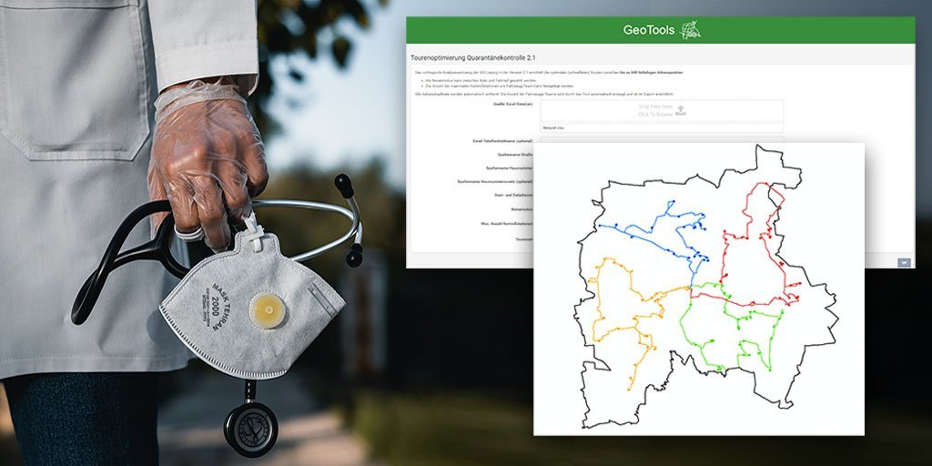
Location intelligence specialist Targomo helps Leipzig’s Health Department to easily schedule multiple home visits to check whether people are in good health and comply with COVID-19 lockdown restrictions. Targomo had earlier supported the city of Valencia to contain the pandemic.
Like many other municipalities dealing with the pandemic, the German city of just over 600,000 citizens is focused on reducing the number of coronavirus infections. People with symptoms or a positive test result need to quarantine at home to minimize the risks of spreading the disease.
To check whether these people remain at home and have not seriously fallen ill, staff of the Leipzig health department carry out hundreds of visits each week. The authority turned to Targomo to help build a fast and reliable routing tool to send employees (up to 15 teams per day) to people’s homes. Leipzig relies on Targomo’s Fleet API service to make this possible.
“By using the Targomo Fleet API as part of Leipzig’s geo data infrastructure, we enable the Leipzig Health Department to conduct more efficient tours for quarantine inspections,” said Charlie Liebscher, a geo data manager of Leipzig’s Office for Geo Information and Land Use Planning.
Targomo’s technology allows the Health Department to find the optimal routes for the different teams. Thanks to the service, Leipzig is able to keep traveling costs and travel time as low as possible, and guarantee an efficient allocation of staff. Employees can choose from two travel modes: bike and car. This allows Leipzig’s Health Department to customize its work and remain flexible during the pandemic.
Leipzig is the second municipality that picked Targomo’s services to help contain the spread of the coronavirus. In spring, the Spanish city of Valencia turned to Targomo to build an easy-to-use app, which its citizens could use to comply with lockdown restrictions. The Valencia tool shows inhabitants how far they can move from their homes, and follow regulations to limit their movements in the city.
Curious to learn more about improving public services? Check our website for more information or the examples further down.
Comments Off on Targomo Supports Leipzig Health Authority to Contain Pandemic

Targomo’s location analytics platform now includes e-bikes as a travel mode to improve the analysis of catchment areas. It enables businesses to better estimate the potential customer base and reach of their locations.
With the rise of electric bicycles used by people and businesses, the inclusion of this transportation mode has become essential to calculate the catchment area of a location. According to one study, an e-biker on average travels more than 60% faster than a conventional biker: 23 km/h vs. 14 km/h (14 mph vs. 8.7 mph).1 This means that the potential customer base of a location could be up to twice as large, depending on the population density.
In Germany, the annual sales of e-bikes jumped to 1.36 million bikes in 2019 from 535,000 in 2015. A third of all bikes sold in 2019 were e-bikes. In the European Union, total unit sales broke the 3 million mark for the first time in 2019, with e-bikes accounting for 17 percent of total bike sales. Even in the car-focused United States, growth rates are in the double digits.2
In addition to more people buying e-bikes, many bike-sharing companies have started offering electric-powered bicycles. Businesses, such as meal delivery companies and logistics firms, have also started using e-bikes and electric-powered cargo bikes as a fast alternative to cars in traffic jammed cities.
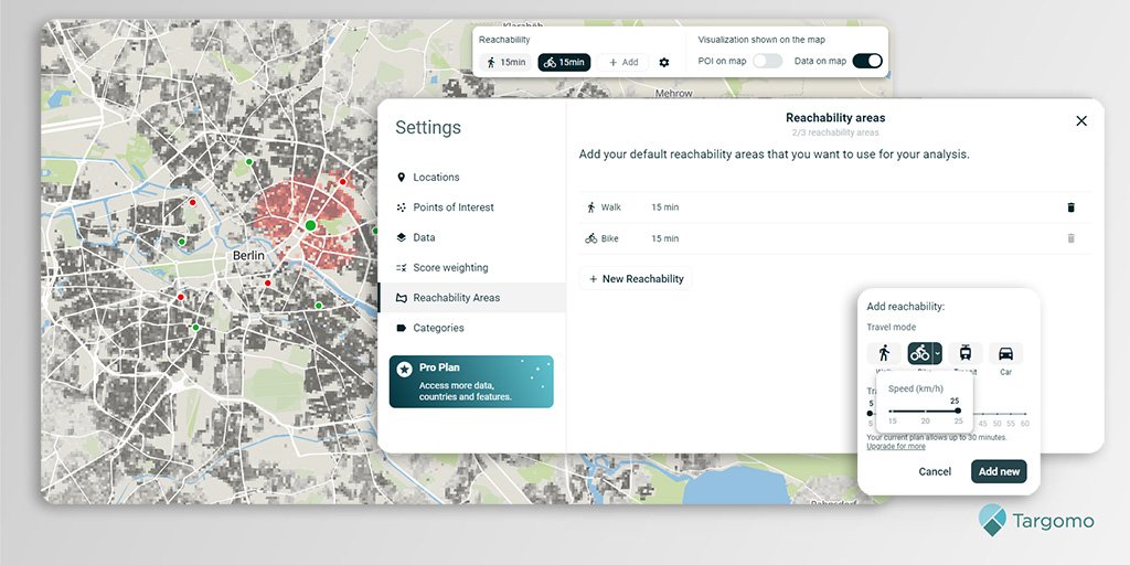
Due to increased usage of electric bicycles, Targomo has added e-biking as a travel mode to its location analytics platform, in addition to walking, normal biking, driving and public transportation. In Targomo’s location analytics platform TargomoLOOP users can customize cycling speeds, choosing between normal biking (15 kilometers/hour or 9 miles/hour) and e-biking (20 or 25 km/h, 12 or 16 miles/h). The platform enables users to calculate the catchment area of locations with demographic, movement and points-of-interest (POI) data.
Many businesses and organizations, from retailers to restaurants and bakeries, from real estate to mobility and public services, can benefit from TargomoLOOP. They can make detailed analyses of locations, catchment areas, and neighborhood characteristics. The inclusion of e-bikes as a travel mode greatly improves these analyses.
The basic version of TargomoLOOP is free of charge and allows users to quickly gain insights into their locations. Curious to see the platform in action? Simply sign up and start analyzing.
About TargomoLOOP
Location analytics platform TargomoLOOP supports managers in retail, real estate, public services and logistics to analyze locations and quickly see their potential in terms of catchment area, customer base and reachability. Knowing how many people and which kind of people a location can attract helps organizations to determine whether it will perform successfully.
The platform offers essential features to analyze locations with maps, demographics, and Points of Interest. Users can easily rank locations by category and correlate location variables with performance. They can analyze an unlimited number of locations and download reports of their findings. No set-up is required: Simply register, type in an address, and get results within seconds. Everyone can start analyzing for free.
Targomo has already helped dozens of organizations in Europe and overseas to effectively use location data. Established businesses such as Oxford Retail Consultants in Britain, Dutch real estate platform Funda, and German beverages retailer Getränke Hoffmann benefit from Targomo’s services.
Footnotes:
(1) Dozza et al., 2013, cited here https://trec.pdx.edu/blog/are-e-bikes-faster-conventional-bicycles
(2) Sales figures taken from https://de.statista.com, https://ecf.com and https://electrek.co
Comments Off on E-Bikes Added as Travel Mode to Enhance Location Analytics
Location Intelligence startup Targomo has launched a new API portfolio and pricing. Targomo is a specialist for highly precise travel time calculations and complex geospatial scenarios. The new portfolio now offers a full spectrum of developer tools to improve map applications. It consists of 10 location APIs ranging from basic map functions to advanced location analytics. All APIs are available on a pay-as-you-go basis. When used for publicly accessible applications, developers get a free credit worth 300 Euros per month. This way, they can try out multiple location APIs to enhance map applications without facing limitations associated to specific plans.
The APIs, which can be accessed through a single API key, are divided into the three categories “Create”, “Analyze”, and “Navigate”:
Targomo’s APIs are used globally, most prominently by real estate, retail, and public sector organizations. Leading Real Estate platforms in Europe such as Seloger or Funda are enhancing their search functions with Targomo by allowing users to incorporate travel time into their search. Delivery services use Targomo’s technology to calculate and optimize delivery routes, and municipalities use reachability analyses to improve their understanding of urban mobility.
Learn more about our API services or get your own API key to get started.
Comments Off on Targomo Launches New API Portfolio
The pandemic poses many challenges to retailers. New regulations come into force overnight and customers’ priorities can change instantly. Location analytics helps adapt to these changing conditions.
While shopping streets have lost a lot of their appeal during the pandemic, local stores have become far more popular. The move to online and omnichannel shopping has intensified due to lockdown restrictions. Home delivery of products and click & collect options have become even more important. To better cope with these short-term developments and its long-term implications, rapid analyses and strategy adjustments are more important than ever. The reachability of a shop or shopping center plays an essential role here.
For many retailers, points of sale are still their main and most important asset to reach customers. Where can retailers best serve their target groups? How many customers can reach a store within 10, 20 or 30 minutes on foot or by car? Where would a Click & Collect service make sense?
Location analytics help retailers answer these questions quickly. By combining data on demographics, household income, Limbic© consumer profiles, and points of interest with a sophisticated reachability analysis, location analytics gives detailed, data-based insights about a location’s catchment area and its potential customer base.
Gain insights quickly
“During the pandemic, it is more important than ever to keep a close eye on individual points of sale and the branch network,” says Noel Carbo, Product Manager with Targomo. “Location analytics enables retailers to gain insights quickly so they can respond to new regulations and market conditions.”
Targomo offers an easy-to-use location analytics platform, TargomoLOOP. The platform helps answer several questions that have become very relevant due to the pandemic:
Let’s take Click & Collect as an example: Location analytics helps to identify the stores with the biggest reach among the population or target groups. By looking at how many people can reach a point of sale in, for instance, 15 minutes by bike, a retailer can see which locations attract the biggest number of people. Shortlisting of locations based on the reach among the population or a specific target group is easy and quick in TargomoLOOP thanks to a ranking feature.
The basic version of TargomoLOOP is free of charge and allows users to quickly gain insights into their points of sale. A premium plan, called Pro, gives companies access to more data and analysis options, such as white spot analysis, household income statistics, and total purchasing power data. Furthermore, Targomo’s premium Enterprise solution uses the full potential of AI and Machine Learning techniques to calculate the sales potential of (new) locations, cannibalization effects and assortment optimization.
Customers such as German beverage retailer Getränke Hoffmann, Oxford Retail Consultants from the UK and French telecoms company Orange already rely on Targomo’s location intelligence solutions.
Curious to see the platform in action? Simply sign up and start analyzing.
About TargomoLOOP
Location analytics platform TargomoLOOP supports managers in different industries to analyze locations and quickly see their potential in terms of catchment area, customer base and reachability. Knowing how many people and which kind of people a location can attract helps businesses to determine whether it will perform successfully.
Targomo has already helped dozens of organizations in Europe and overseas to effectively use location data. Established businesses such as Oxford Retail Consultants in Britain, Dutch real estate platform Funda, and German beverages retailer Getränke Hoffmann benefit from Targomo’s services. The platform allows every organization to quickly and easily analyze locations and gain new insights.
Comments Off on How Location Analytics Supports Retailers During and After the Pandemic
Comments Off on Location Tech Startup Targomo Launches New API Portfolio